The Battlefield
The battle was fought in two main areas, firstly and most significantly, at the site of the initial clash and majority of the fighting, on the main Wigan to Warrington road and either side of it, at Red Bank. This was, to begin with, most likely to have been contained in a fairly narrow area, although when Cromwell sent his cavalry to outflank the Scottish position, fighting would have been over a wider area. In addition skirmishing or even a more prolonged firefight would have taken place against and by the Scots along the southern edge of the valley, probably both to the west and also to the east of the road. It is possible the initial Scots’ line to the west of the road ran to the north into the area defined by the horseshoe bend of the Newton Brook. This would have utilised the higher ground in the Red Bank area, near the current New Hay Farm, although the Scottish left flank may have been refused, running back below Cop Halt Farm to the south of the Newton Brook horseshoe bend. Integral to the battlefield in this initial and main phase of action, are the areas where both armies deployed, the route taken by Cromwell’s outflanking cavalry and the areas of fighting.
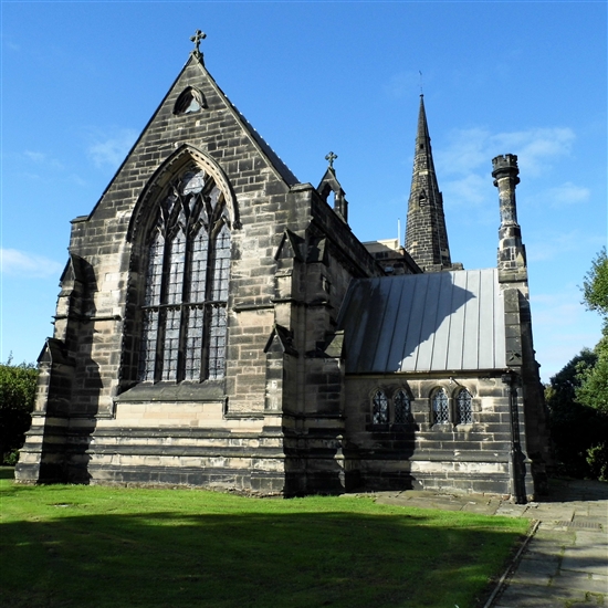
Secondly, the area where the final stand was made was also an area of close fighting. This is in the area termed ‘Winwick Green’, as well as the church itself and possibly Winwick Hall.
Linking these two distinct areas is the land over which the retreat of the Scots took place during the battle.
The first and main area of deployment, manoeuvre and fighting is clearly at and around the area where the main road crossed the Hermitage Brook in 1648. From various 19th century maps it shows that the road alignment has not changed since the date of these maps to the present, and it seems reasonable to assume the same is true of the preceding c.150 years, given the nature of the Newton and Hermitage Brooks' confluence with boggy ground to the west and east of the road and the sandstone bank to the east. One change is from the 1745 Estate Map of Newton-in-Mackerfield (modern transcription at http://newton-le-willows.com) where the road to the north of the Hermitage Brook is shown as not being as straight as it was by 1831, with these improvements being made in 1811. The junction of the main road to Winwick with Hermitage Green Lane is shown on the 1745 Estate Map. Steven Dowd suggests that the earlier main route between Newton-le-Willows and Wrinwick was along Hermitage Green Lane, before a now lost track/road ran south to Winwick across what are now field boundaries, although when the change to the current road from Red Bank to Winwick occurred is not clear. Whether this was the case, and until it could be tested archaeologically it is likely to remain unclear, the main initial fighting in the battle would still have taken place in the same area i.e. just to the south of the Hermitage Brook along the line of the current Red Bank to Winwick road, with the possible addition of some fighting to the west of the main road and to the north of Newton Brook, if this higher ground was occupied by the Scottish force at the start of the battle. Scottish musket fire would undoubtedly also have carried across Newton Brook as the parliamentarians advanced. This main location of the initial fighting is reasonably clear, because any forcing of the “passe” at Red Bank would have led to a retreat southwards away from the parliamentarian forces, rather than along Hermitage Green Lane as suggested by Stephen Dowd.
Deployment of the parliamentarian forces, once it became clear the Scots were making a stand, would have initially been in Newton Park, now the former Parkside Colliery site, and then along the northern slopes of the valley to the east along Hermitage Green Lane and to the west by Red Bank. Post-battle development has affected much of this area, although some of the former area appears to be relatively intact, despite the presence of the colliery from 1956.
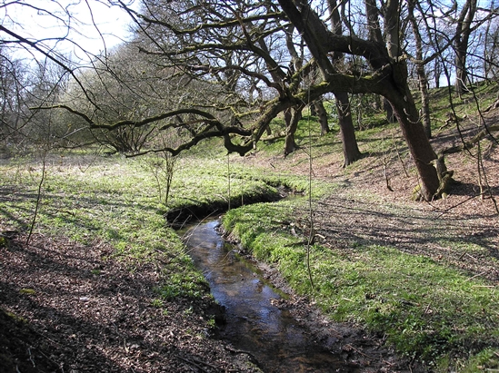
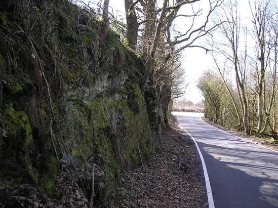
The sandstone bank running along some of the line of Hermitage Green Lane would have presented a formidable obstacle to the attacking parliamentarians and partly suggests why this spot was chosen as the place for a holding fight, especially when combined with the marshy ground and watercourses on both sides of the main road. These difficulties of terrain would have meant an initial attack on a very narrow front, along the line of the road where it crossed the Hermitage Brook, hence the use of the word “passe”, with only skirmishing across the valley possible to the east. Local tradition has Cop Halt Farm on its high ground as the location for the Scottish headquarters. Copies of various 19th century maps are available online at http://newton-le-willows.com with the presumed site of the battle being marked on the maps of 1849 and 1891 and later, marked as Red Bank, just to the east of the main road south of Hermitage Brook. This location is also marked as the site of the battle on the 1:25000 Ordnance Survey map used as the basis for the map at http://www.streetmap.co.uk.
The route of Cromwell’s cavalry attack is likely to have been around the eastern flank of the Scottish position, given the difficulties of the ground to the west and the sandstone bank immediately to the east of the main road. This would suggest a route through Hermitage Green.
The area of fighting in the second and final part of the battle in Winwick itself, is likely to be largely built-over by development subsequent to the battle, although at the time is more likely to have been among enclosures on the edge of the township of Winwick, including the area known as Winwick Green and in the churchyard and church. Local historians have also suggested that Winwick Hall and its grounds may have been involved in this part of the battle.


