Battlefield Walk
6 miles. Starting from the Abbey Park in the centre of Evesham. There are several car parks near the centre. The route is partly along metalled footpaths beside roads, partly on un-metalled lanes and partly on well marked footpaths across pasture. Just one small area along the Avon bank can be boggy, especially after wet weather. There is a full range of facilities within the town of Evesham. The walk described here is meant to be used in conjunction with the Evesham battlefield OS Explorer map, which can be downloaded from the left hand side of the screen on the main battle of Evesham page on this website.
If a much shorter walk is required, then there is parking adjacent to The Squires. This road is closed at its western end, where it is possible to park. This gives access to the walk to the Leicester Tower and the Obelisk. It is also possible to park on the old road beside the main road to Alcester, immediately to the north of the junction with the Squires.
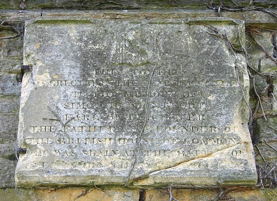
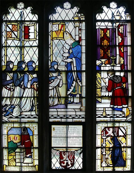
Start from the Abbey Park in the centre of Evesham at the de Montfort Memorial just to the south of the tower of the Abbey church, overlooking the river Avon. This is the sixteenth century tower replacing the original medieval tower a little to the south from which supposedly, de Montfort’s barber saw the approach of the royal army. The 19th century stained glass in a window in the north aisle of St Lawrence’s church is worth a visit. Also keep an eye out for several interpretation panels around the grounds which describe the Abbey itself, giving a good impression of the character and layout of the abbey in the medieval period. Almonry Heritage Centre with its Battle Room is also just a short walk to the north west of the Abbey site.
From the abbey, walk north along the High Street. On the east side of the road near a pedestrian crossing are paving stones which show the names and coat of arms of the leading participants. Continue north out of the town along the Alcester road, following the route taken by de Montfort’s army up onto Greenhill. Today the suburbs of the town stretch right up to the battlefield, but in 1265 the town stopped just a short distance north of the market place.
Just after reaching the brow of the hill, opposite Collinsfield, is Battle Well House. This should not be confused with the site of the Battle Well. It was however close by here that burials were found some time before 1857 – possibly rebel troops killed during the pursuit. There is a small lane that gives access to the hilltop a little to the south of Battle Well House, on the west side of the road, but this is not a public right of way.
Continue north. Just before Blayney’s Lane, which is on the east (right hand) side of the road, is a footpath on the other side of the road that leads between the houses to the site of the Battle Well. This is a permissive right of way. Battle Well field is now tenanted by the Simon de Montfort Society with an Interpretation Board there. A sign posted walk, starting from there but best done separately to this walk goes through the western part of the battlefield and leads up to The Squires, which provides access to the Leicester Tower and Obelisk in the grounds of Abbey Manor House (see also below for a different approach to these monuments). This is mainly on permissive rights of way through agricultural land so please be sure to observe the Countryside Code. Battle Well is where, according to tradition, de Montfort fell. Close by a chapel appears to have been constructed in the medieval period but its exact site is not known. You are now probably just to the north of de Montfort’s initial deployment at the beginning of the battle.
You can also continue north along the Alcester Road and turn left along The Squires. This is probably the location where the royal forces deployed, with de Clare’s division to the east, Mortimer’s to the west and Edwards perhaps across the line of the main road. Go past the entrance to Abbey Manor House. 200 metres further on there is a gateway on the left. If you look along the line of The Squires north westward beyond the gateway you can see the wooded hills adjacent in the distance which lie close to the site of Mosham Meadow where Edward’s army rendezvoused before marching on the final approach to the battlefield. De Montfort’s army was probably already in battle array on Greenhill when Edward’s three divisions march up this road, the old Salt Street, to deploy.
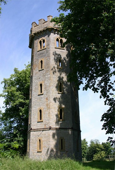
From here there are waymark signs that lead you to the Leicester Tower and the Obelisk. Having passed the Tower and gone through the trees, when you reach the stile where the path turns north east up the slope to the Obelisk, look to the south east. From here it is possible to see the tower of the abbey in the valley to the south east and further eastward the rise up onto the top of Greenhill and around to the east the site of the Battle Well is just visible at the head of the small valley.
From the Obelisk retrace your steps to the top of the Squires. Take Blayney’s Lane on the other side of the main road. This leads you down the hill towards the site of Offenham ferry. The bypass now cuts across the line of the lane necessitating a slight diversion, Take great care when crossing the bypass. The path leads a short distance along the line of the old railway line. This is the site of the Siveldestone, the Saxon marker stone near which one of the accounts says the royal army deployed. Maybe the left wing of the royal army was indeed deployed well down the slope toward the stone. Take the path across the small pasture field towards the river. Deadman’s Ait, which was once a small island encompassed by the Avon, is the tree covered land immediately adjacent to the river. On the other side of the river, close to the site of the medieval bridge which used to give access across the Avon to Offenham, is a pub, but sadly for the thirsty walker it is no longer accessible from this side of the river!
From here follow the path south along the bank of the Avon. There are good views of Greenhill across the meadows, giving a good feel for the steepness of the slope, though on this side of the Alcester road the whole of the hilltop has been built over in the 20th century. Continue along the path until it takes you back into Evesham. Take the first opportunity of a linking path that takes you up onto the main footpath from Oxstalls Farm as this is an easier walk along the last short stretch into the town and back to the starting point.
For an alternative, shorter walk to Deadmans Ait, go to Evesham Country Park (WR11 4DS) at northern end of A46 Evesham bypass. At rear end of car park there is a track which leads down to the River Avon. Before you reach the river turn right onto a footpath which takes you along the river bank. After about 400 yards another footpath on the left takes you onto Deadman’s Ait and then to a foot bridge over a small stream into the field opposite the pub at Offenham. Return the same way. (NB Deadman’s Ait can get overgrown in summer).


