A Battlefield Drive

Ideally a driving tour should start from the A5 near Atherstone and follow what is believed to be the route of Henry’s advance to the battlefield.
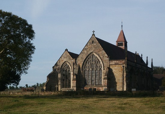
MEREVALE ABBEY
The visitor with plenty of time may wish to go first to see the abbey church at Merevale, which was possibly the headquarters of Henry’s army on the night before the battle. From the A5 just to the north of Atherstone take the B4116 south west, signed to Coleshill. The Abbey church is on the left hand side of the road where it climbs the hill. There is easy car parking immediately next to the gatehouse. The church can be viewed with difficulty from the road. Access to the church is through the small gate on the larger doors of the gatehouse, which gives access to a private courtyard, with the church on the south side. However to enter the church it is necessary to collect a key from Atherstone first and so prior arrangement should be made. The phone number for the Rectory given on the information board at the church is 01827 874252.
FOLLOWING THE ADVANCE TO THE BATTLEFIELD
From the A5 just to the south of Atherstone take the local road east to Fenny Drayton. This is the Fenn Lanes Roman road, believed to be the route by which Henry’s army approached the battlefield.
Fenny Drayton is one of the villages paid compensation some time after the battle, in recognition of the losses it suffered, presumably at the hands of the troops quartered there the night before the battle. Drive through the village, turning left towards Sibson in the centre, and on the other side of the village cross the A444, following the sign towards the Battlefield Visitor Centre.
About 400m (450yds) along the road on the left had side just inside the field is the large mound that has been claimed as the burial site of dead from the battle, but has been shown by excavation to actually be where a windmill once stood. Continuing eastward, the road passes over a low hill and then in front of you lies the shallow basin of Redemore. About 2 miles from the A444 you pass a turning to Stoke Golding on the right and then Fenn Lane Farm. You are now entering the area which once was poorly drained moorland. Where the road crosses a small stream is the first area where marsh probably existed in 1485, then passing turnings on right and left you climb over a slight rise. This is probably where Henry’s army made its outflanking move, turning north to skirt around the marsh. Continue on towards Sutton Cheney and you cross another tiny stream. This is where the main area of marsh is believed to have lain. On the other side the ground rises a little and it may have been here that Richard’s army was deployed. However it is more likely to have been further to the east.
DADLINGTON CHURCH
If you wish to visit the medieval church at Dadlington church, where a chantry was established in memory of those killed in the battle, then turn right to the village of Dadlington. The church is on the right immediately after you enter the village. Take the first turning right, where it is possible to park along the road. A good view across Redemore can be obtained by walking along a footpath which crosses the paddock on the other side of the road north of the church.
Return to the Fenn Lanes and turn right towards Sutton Cheney. Where the Fenn Lane bears left it crosses another stream, known as the river Sence. It may be here, on the east bank that Richard first deployed his army.
SUTTON CHENEY
Continue on up the hill into the village of Sutton Cheney. Some believe that it was here that Richard’s army was quartered the night before the battle and that he heard mass in the parish church on the morning itself. There is a small exhibition and a memorial to Richard in the church, in the centre of the village.
BOSWORTH BATTLEFIELD VISITOR CENTRE
From Sutton take the road towards Shenton, signed to the Visitor Centre, which lies a mile out of the village on Ambion Hill. It is well signposted. Parking and access to the Visitor Centre both have to be paid for but it is well worthwhile. It does have some good interpretation material as well as a shop, café and toilets. From here you can walk to King Richard’s Well and view other markers along the battlefield trail provided from the Visitor Centre, which is where the battle has been described as taking place ever since Hutton wrote on Bosworth in the late 18th century. However it does not now appear that the battle took place here on the slopes of Ambion Hill or that Richard’s Field was the location where Richard III actually died.
It is possible to walk from the Visitor Centre to the probable site of the action, but it is a long and circuitous walk. It is better to drive to the Whitemoors car park to start a battlefield walk.


