Battlefield Walk
4 miles. Mostly over flat terrain, partly by minor roads and part by footpaths through pasture fields. There is a very long and steep descent and re-ascent (100m) of the Edge Hill scarp.
Refreshments and toilets are available at the Castle Inn at Edgehill and toilets are available at the rear of Radway Church
The walk described here is meant to be used in conjunction with the Battlefield Explorer map, which is available from the download area on the left of the screen.
A walking tour of the battlefield is best begun at the Castle Inn on Edgehill. It is possible to park along the road near the pub. A narrow band of trees has been cut immediately below the Castle Inn, to give an impressive long distance view from the pub garden across to the battlefield and more widely over the Vale of the Red Horse. However the width of the prospect is severely constrained by the trees on either side. By far the best views broad view of the battlefield is gained from the lower slopes of Edgehill, immediately below the woodland.
Exiting the pub door, turn immediately left down a narrow path that leads down into the trees. The path drops rapidly down the hillside, giving a real feeling for the difficulty faced by the royalist infantry as they descended to the field at the beginning of the afternoon of the 23rd October. By the time you reach the gentler slops below you will have appreciated why the cavalry and artillery had to find an easier route! Where the path comes out of the woodland there is a wonderful view across the Vale. The village of Radway lies at the bottom of the slope, with the battlefield beyond. The MOD depot with its reinforced ‘igloos’ for munitions storage, all encompassed by a high security fence, is clearly visible, marking the right half of the parliamentarian deployment. In the pasture field in which you stand there are ridge and furrow earthworks from the open field system, which was still functioning at the time of the battle, each ridge representing an original individual ownership strip. One could not ask for a better context within which to try to appreciate the battlefield landscape as it was in 1642. Take away almost all the hedgerows beyond the village and replace them with the unenclosed strip system that you see before you, which will have been part ploughed and part fallow in October 1642, and you have an open field landscape ideal for the ‘chessboard’ deployment of 17th century armies. But on the far right and left of your view the landscape was already fully enclosed at the time of the battle and so there one needs very little imagination to conjure up the landscape of 1642.
As you descend through the ridge and furrow note the monument in the field to the right. It has no connection with the battle of 1642, but commemorates events of a much later period. Look back up to the Castle Inn. The tower itself was a folly constructed in the 18th century as part of the parkland landscape which is all around you, designed by someone with an antiquarian’s interest in the battle.
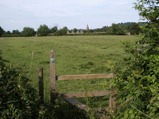
You enter the village by a small pond. On the far left side of the small green is a narrow entry between the stone built houses which gives access to the site of the medieval churchyard of Radway. The church was demolished in the 19th century but many of the gravestones still remain. Return to the green and turn left down the lane to the main street. The present church is just along the main street to the left. It was built in the 19th century. Inside you will find the monument to a royalist officer unlucky enough to have been killed by roundshot fired from a parliamentarian cannon and a musuem exhibition about the batle and it impact on the local population opened in October 2015. In the graveyard on the left hand side as you leave there is another remarkable monument, completely unrelated to the battle, which commemorates deaths in a car accident in 1899!
From the churchyard turn right. The street turns to the left and a short distance after the bend take the footpath on the right. This leads through another field of ridge and furrow. From the far end of the field there is a good view out cross the battlefield from just behind the probable position of the royalists left wing at he beginning of the battle. Where the path reached the road once more look to the north. Beside the road, just inside the next field is a large mound with trees on. This is the traditional site where the king’s standard is said to have been raised.
Turn right along the road to the sharp left hand bend. The lane in front of you is now closed to public access but it used to lead right across the battlefield to Kineton, before the MOD depot was constructed. From the gateway at the corner one gets a good view across the flat ground north east along what e believe to have been the approximate frontage of the initial royalist battle array.
Retrace your steps towards the church. Back on the road, at the corner just before the church, take the footpath leading off to the left. This takes you to the Kineton road out of the village. At that road turn left and follow it for half a mile until you see a seat on the right hand side. This road is aligned approximately parallel ut a little behind the roaylist’s original deployment. In one or two places along the road there are views out to the north west but it is difficult because of the high, unmanaged hedgerows and new planting to see the slight rise in the ground about half a mile away where the parliamentarian army stood in battle array. The gateway to the right gives excellent views north east to Knowle End on the end of Edge Hill, while the very distinct mound in the field in front of you marks the site of Kings Leys Barn, where Balfour came close to capturing the two princes in his attack on the royalist artillery late in the battle. Several of the hedgerows here existed at the time of the battle. Ongoing research may prove that this is where the royalist infantry took up a defensive position after being pushed back by the parliamentarians in the last stages of the action, but they may not have been pushed quite this far back.
Now retrace your steps into the village. At the T junction turn left and then immediately right up a narrow lane, following the footpath sign leading back to Edge Hill. Again you pass through former parkland and areas of ridge and furrow earthworks. When you approach the edge of the woodland look back, for here is another excellent view across the battlefield
Into the woods the path then ascends via Jacob’s Ladder, leading out onto the top of Edge Hill. At the top turn right along the footpath beside the road to walk the last third of a mile. As one ascends the steep scarp today one has the benefit of the steps, yet it is still a tiring climb. It is difficult to imagine how the royalist infantry must have felt as, battle weary in the dark and biting cold of the early morning, they struggled back up this steep slope from the battlefield to the security of the hilltop. There was no inn there in 1642 but today the weary battlefield tourists have the thought of refreshment to encourage them as they trudge to the top of the scarp – if of course the pub is open by the time you return, as we found it was not when we researched this walk on a Sunday afternoon close to the anniversary of the battle!


