Historic Terrain
The key topographical facts are that the Viking force landed or marched to a position on one side of a channel of the Blackwater estuary or a tidal section of the river, then called ‘Panta’. At high tide they were unable to cross but it was a sufficiently narrow channel to allow the opposing forces to negotiate by shouting across the water. When the tide fell and they were allowed to cross they did so, across a causeway (brycg) or ford, in a westerly direction.
There have been three main candidates for the Maldon battlefield. One lies immediately north east of Maldon at the place now known as Heybridge, now completely built up as a suburb of Maldon. The Viking force was suggested as having crossing north eastward from just outside the Maldon defences to attack the East Saxon army on the north east bank. The case for this site has been comprehensively demolished by more recent authors, because it does not apparently meet the criteria relating to the tides while the poem makes no reference to Maldon town which would have been immediately to the back of the Viking force.
The second candidate was Osea Island, which lies in the north of the estuary and is connected to the mainland by a causeway. But the distance between the island and the mainland, at circa 1 km, is too great, even when sea level rise is taken into account, to fit the events in the poem which has the two sides communicating by shouting across the water.
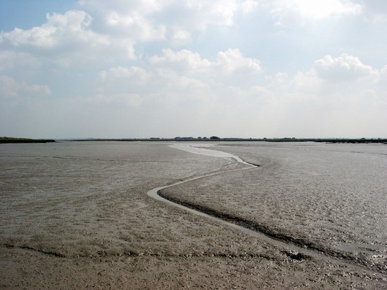
The strongest candidate is that of Northey Island, which has been shown to fit very closely the topographical features described in the poem, including the way in which the rising tide flows around both sides of the island to meet at the causeway. While today the distance from mainland to the island might be considered too great for a shouted exchange, it has been shown in this region of England the land has been sinking since the last ice age and that since the 10th century sea level has risen by about 6ft. As a result there are now saltings where there was dry land in the 10th century, making the channel no more than about 110m wide at that time. The adjacent land was dry pasture ground dipping gently to a steep river bank. In 991 the causeway will have been covered by 6-8 ft of water at high tide, while silts similar to those seen today will have made crossing the channel impossible except by a causeway.
According to the poem there was a wood nearby for one Englishman let his hawk fly to the wood before he advance to battle, while later others fled to the woods after Byrhtnoth’s death. The parishes to the west of Northey Island have woodland related names, Woodham and Hazeleigh and Purleigh. However no detailed reconstruction of the distribution of woodland in this area in the medieval period has apparently been attempted so it is unclear how closely the woodland might have extended towards the battlefield.
As a result of sea level change Maldon is very unusual amongst English battlefields in that not only human but also natural agencies have dramatically transformed the character of the landscape since the time of the battle. A good deal of the area of the presumed battlefield is now slightly below sea level. This has long been protected by a sea wall, although as late as 1881 some of the area was still subject to periodic flooding. The flood banks are today a dominant feature of the landscape while at the northern end of the presumed battlefield a landfill site, now completely fenced in, has completely altered the ground levels and character of the area.
The main works on the historic terrain are:
- Petty G.R. and Petty S. 'Geology and The Battle of Maldon', Speculum, 1976
- Petty and Petty. A geological reconstruction of the site of the battle of Maldon, in Scragg D.G. The battle of Maldon: fact or fiction?, 1993


