Battlefield Walk
The walk described below is meant to be used in conjunction with the battlefield OS Explorer map, which can be found in the download area on the left of the screen. A leaflet from Nottinghamshire County Council showing the walk can also be downloaded by CLICKING HERE
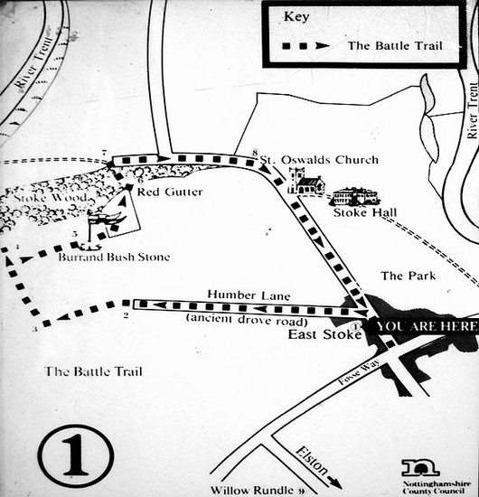
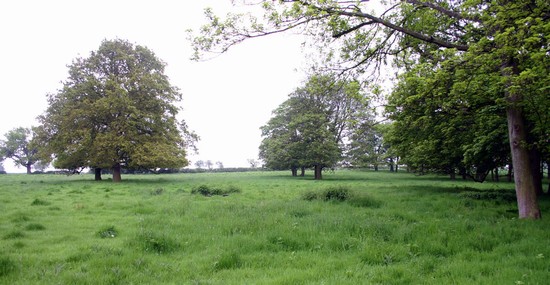
Stoke is not the easiest battlefield to explore because the location of the deployment of the two armies and the course of the fighting is not adequately understood and some of the best viewpoints are on private land. New interpretation panels were installed in June 2018 and a new battlefield trail launched, which offers a good overview of the battlefield and the possible deployments of the royal and rebel armies. The walk gives a good feeling for the overall character of the terrain and enables the visitor to consider some of the tactical opportunities that existed and to review the various possible interpretations of the action. The new trail replaces the battlefield trail created in 1987 for the 500th anniversary of the battle, which long ago fell into disuse, although the interpretation panels can still be seen in the bell tower of St Oswald’s Church, which you will pass as part of the trail.
The starting point for the walk is on Trent Lane (SK 746485), which is diagonally opposite Eden Hall Day Spa. There are laybys located on either side of the Fosse Road about 300 yards from the start of the battlefield trail. There are also bus stops outside Eden Hall for the number 90 bus route between Newark and Nottingham, which is operated by Marshall’s of Sutton-on-Trent. They also operate the number 91 from Newark to Bingham, which also stops outside Eden Hall.
The battlefield trail crosses open working farmland, therefore visitors should keep to the paths identified on the trail and keep any accompanying dogs on a lead. The trail is over a stony public bridleway, a footpath and then metalled roads and pavements. At certain times of the year the footpath may be wet and muddy, therefore suitable footwear and clothing is advised. There are no toilet facilities near the trail.
The trail should take approximately 1.5 hours to complete. It is not suitable for people with mobility problems or for buggies.
Battlefield Trail
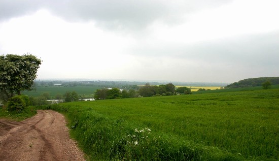
The trail begins at the bottom of Trent Lane. Go through the barrier and approximately 100 metres on the left you will come to the first panel, which will give you some information about the lead up to the battle. The road behind you is the Fosse Road. This is the old Roman road, known as the Fosse Way, from Exeter to Lincoln. It is the route along which most authors claim part of the royal army advanced, having spent the night before the battle at Radcliffe-on-Trent. It is thought that around 9000 royal troops advanced in two columns, one led by Henry VII and the other by Lord Strange. The vanguard of 6000 troops, led by John de Vere, Earl of Oxford, probably advanced along the Upper Fosse, led by local guides from Radcliffe. Some interpretations of the battle place the royal army deployment in a roughly east – west direction across this area, facing a rebel deployment on the hilltop. The rebel army had probably crossed the River Trent by a ford at Fiskerton, or possibly at Newark and had spent the night of the 15th June on the high ground. According to this interpretation the rebel army then advanced down the hill to engage in the fields to the north of your position.
Now follow the track in front of you for approximately 10 minutes until you meet another track (Humber Lane), that joins from the right. You should now see panel two on your left. This will give you information on how the battle was fought.
From this point you can see the hill to the right of the track on which Burrand Furlong is situated. This position dominates the Fosse Way to the south, and the Trent Valley to the north and east. The 8000 strong Yorkist army was clustered in a single mass on the high ground south west of East Stoke. Humber Lane forms the line of the Upper Fosse and if you track it to your left it continues across Syerston Airfield and on to Radcliffe-on-Trent. This is the road that the Earl of Oxford’s 8000 vanguard is thought to have approached along. It may be that the Yorkist rebels thought they could defeat the vanguard before Henry VII and Lord Strange arrived. The battle is thought to have begun around 9 AM and lasted for around 3 hours. One of the sources reports that the lightly armed Irish troops suffered most from the royalist archers and were ‘shot through and full of arrows, like hedgehogs’. Eventually the battle turned into a rout and all the leading rebels, John de la Pole, Earl of Lincoln, Martin Schwartz and Fitzgerald were killed and Lambert Simnel was captured. The only Yorkist leader to escape was Francis Lovell.
Please do not enter the track on your right. This is private land and there may be working farm machinery using this for access.
Follow the left lane, which will bend round to the left before proceeding steeply downhill to the River Trent.
You will have a good view of just how steep the escarpment is down which some of the fleeing rebels must have stumbled. Across the river you will be able to see Fiskerton. It is thought that the rebels crossed a ford here the night before the battle. The River Trent is now much narrower and deeper than it would have been in 1487. The course has also changed and it was canalized in the 18th century. While the floodplain would have been meadow, this higher ground, would in part at least have been open common before enclosure. The rest of the land here will have been under arable open field furlongs, with few if any hedgerows in 1487.
Continue down the lane to the river, then turn right and walk through the hedge boundary in front of you. Follow the left hand path along the field edge, keeping the river on your left. Continue on this path towards the wooded area, where you will see panel three just below the Red Gutter. It should take around 30 minutes to walk between the two panels.
The third panel will give you information about what happened at the end of the battle. The steep wooded area to your right front is known as Red Gutter and local legend tells that it ran red with the blood of the rebel soldiers who were killed trying to escape. Another possibility is that it is named after the red Keuper Marl clay in this area.
On the left the flat pastures and arable fields of the floodplain, which were enclosed in the 18th century, would have been meadow and marshland at the time of the battle. Earthwork evidence of ancient river channels can be seen running through this area on the 1940s aerial photographs and close to the road in the field one such feature can still be traced, running parallel to the lane. Across the river you can see the village of Fiskerton and it is likely that some of the fleeing rebels tried to get to this crossing of the Trent and drowned in the process.
Please do not enter the wooded area of the Red Gutter as this is private property and potentially dangerous.
Now follow the path, keeping the wooded area on your right and the hedge on your left. Continue past the hard standing onto the path in front of you, until you come to panel four on the bend before the church. This should take approximately 10 minutes to walk.
Panel four will give you information about how the dead were buried after the battle and about the human remains discovered when a drainage ditch was being dug in 1982.
There are a number of mass graves reported from the 19th century, as well as the more recent discovery. All lie on the south western edge of the former gardens and hedged enclosures of East Stoke village. All the ground to the south west of here, where the action was fought, was almost certainly open field or common and lacked any hedgerows in 1487. If these graves are related to the battle, then it is likely that many of the routed rebel troops were caught and dispatched by the pursuing royal forces as they tried to funnel between the enclosures where the roads passed through the village.
If you have time visit the church of St Oswald. There has been a church on this site since the 13th century. The gate for the church is on the left, just before the arch across the road. Please do not use the path leading to Stoke Hall to access the church. The battlefield monument was erected as part of the 1987 commemorations and is set against the outside south wall of the tower. There is the usual spurious tradition, reported by Clarke (1993), that the battered stonework at the church entrance is due to the sharpening of swords prior to the battle. Inside the church, in the base of the tower, the 1987 interpretation panels are on display (The tower door is not normally locked but just stiff).
On leaving the church turn left and follow the footpath through the village to the junction where School Lane meets Fosse Road.
Another mass grave, reported in the early 19th century, probably lay somewhere in the field on the right just after you pass under the arch. The brick boundary wall to Stoke Hall Park is on your left and on your right pasture fields. In the 18th century this was still part of the village but the houses were probably removed when the landscape park was developed. The earthworks of the former houses and gardens can be clearly seen in this field on the right.
At the junction turn right and the fifth and final panel is on your right, close to the rose bed, which around the anniversary of the battle is full of red roses. A rose bed of white roses is on the other side of the road.
The fifth panel will give you more information about the ‘lost’ village, through which you have passed, which at the time of the battle would have clustered around the church.
This concludes the battlefield trail. If you are returning to cars parked in the laybys follow the Fosse Road to the right until you reach the laybys. This should take around 20 minutes to walk. If you are catching a bus there are bus stops on both sides of the road close to the fifth panel.
FURTHER READING
All walks for this battlefield show broadly the same route, simply because of the limitations of the footpath network. The English Heritage Battlefield Hike (7ml), gives almost the same route as presented here but in reverse, and with the addition of a visit to the site of the Fiskerton ford. The walk presented here is almost exactly that given by Clark, but again in reverse order, with parking at Elston. Kinross shows a walk from the end of the Humber Lane to the Burrand Stone and then down the Red Gutter to the Trent. This was part of the 1987 battlefield trail, which is now defunct, and as this section was not on a right of way there is no longer access along this route.
-
Clark, David. Battlefield Walks: Midlands, 1993.
-
English Heritage. Battlefield Hikes volume 1. London: English Heritage, 2003.


