Driving the battlefield
About 15 miles. Mainly along minor roads.
The battlefield is a heavily hedged and treed landscape and some of the hedgerows are not well managed. As a result, especially on the very flat landscape of the vale itself, views from the roads are often severely restricted.
The Castle Inn at Edgehill is the most distinctive landmark in the area and makes a good start / end point for a driving tour of the battlefield. From the pub garden you can get a good view of the battlefield, with the MOD base at its heart, and Kineton village in the distance.
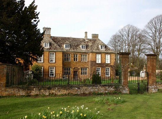
From the Inn turn left, driving north east along Edge Hill. If you wish to visit Warmington churchyard, to see the Civil War gravestone of Captain Gourdon, then drive past the right hand turn to Ratley and, ¾ mile from the pub, take the right hand fork to Warmington along the B4086. Then after a further 2 miles, at the T junction, turn left on to the B4100. The church is on the right as you start to descend the hill. There is a lay-by on the right hand side of the road, next to the churchyard. Returning from the churchyard continue down the hill and after 1 mile turn left to Arlescote. It is possible to park in this hamlet to view the outside of Arlescote House, the large stone house on the right hand side, behind a high stone wall with gazebos at the corners. This is where the two princes, Charles and James, were quartered on the night before the battle. Continue through the village to the T junction and turn right towards Kineton onto the B4086.
If not taking the Warmington diversion, take the left fork onto the B4086 towards Kineton. This leads you down the scarp, possibly the route taken by Rupert’s cavalry on the afternoon of the battle, although further research might reveal that the road has been realigned since the 17th century. There is an excellent view of the battlefield from Knowle Hill, where the B4086 comes out of the woodland as it descends Edgehill into the Vale. However there is nowhere safe to park in this area so only the passengers will be able to briefly appreciate the view. It is here that those taking the Warmington diversion rejoin the main route.
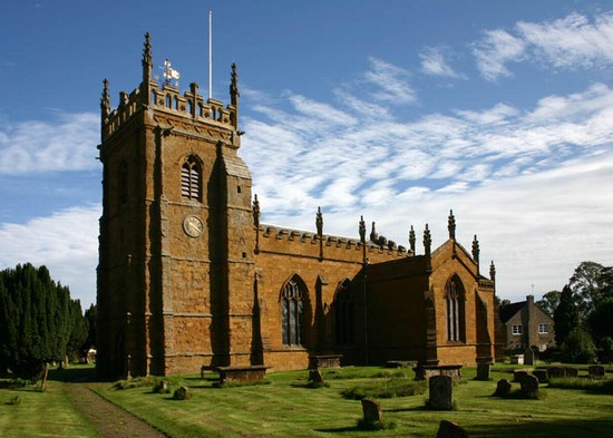
At the bottom of the hill take the first left into Radway village. Drive through the village towards the church at the far end. However, it is best to take the first left just before the church as it is possible to turn around at the end of this dead end lane, as the drive continues from the church back through the village towards Kineton. It is possible to park at various points along the village street. The old churchyard is down a small alley at the north west corner of the green at the end of the lane. Return to the north end of the lane. Walk the short distance to the present church along the main street to the left. Here you will find the Kingsmill monument and a musuem display about the battle.
Drive back eastward along the village street taking the left hand turn in the village towards Kineton. A quarter mile out of the village the road curves around to the right. The road here runs roughly on what we believe to have been the alignment of the royalist battle array at the beginning of the action, though probably they were a few hundred yards to the left (west) of the road. There is room to stop on the right hand side near to a seat. The gateway to the right gives excellent views north east to Knowle End on the end of Edge Hill, while the very distinct mound in the field in front of you marks the site of Kings Leys Barn, where Balfour came close to capturing the two princes in his attack on the royalist artillery late in the battle. Several of the hedgerows here existed at the time of the battle.
Continue along the road to the T junction and turn left on the B4086. This road takes you along the line of Rupert’s cavalry charge at the opening of the battle. The road turns a little to the left and then where it turns back to the right, that corner probably marks the main hedgerow running right to left which the parliamentarians had lined with musketeers to fire on the advancing royalist cavalry. Immediately beyond this, before you reach the monument you pass through the position of Ramsey’s cavalry deployment on parliament’s left wing. The monument is on the left hand side and there is a small lay-by in which to park. An informal parking area has also developed on the verge on the other side of the road because of the small size of the layby. Unfortunately the high hedgerows preclude any effective view of the battlefield. It is however possible to walk the 450 metres back towards Edgehill, past the entrance on the south side to the Edgehill depot, to the bend. Here one can look through the gateway on the south side of the road. The hedgerow on the right hand side of the field, existed in 1642 and is almost certainly the one behind which the parliamentarian cavalry took up a defensive deployment at the start of the battle, the hedge itself lined with musketeers. This hedge extended about half way across the battlefield in 1642.
From the lay-by continue on to Kineton, following the line of the parliamentarian rout, where Rupert’s cavalry ran pell-mell amongst the fleeing troops, doing considerable execution. In Kineton, park on the main road by the church in the centre of the village. This is the church which the Earl of Essex was attending on the morning of the battle, to hear the Sunday service, when news arrived of the royalist army assembling on Edgehill. Turn left immediately opposite the church entrance, and drive south towards Little Kineton. After ¼ mile, in Little Kineton, turn left towards Tysoe. Take the left fork after half a mile. This road skirts almost a mile from the battlefield on the south west side. Most of this landscape was enclosed pasture fields at the time of the battle and so little or no action is likely to have extended this far to the south west. At the crossroad with the A422 turn left to climb up Sun Rising Hill onto Edge Hill. This is believed to be the route by which royalist cavalry descended into the valley on the day after the battle to recover the artillery that had been left in the field. Less than half a mile after the crest of the hill turn left back towards the Castle Inn at Edgehill.


